Our Trail Spotlight highlights day trips to multi-day hikes across Idaho. Trail conditions can change quickly- swollen rivers can become impassable, windstorms can knock trees down across trails, and snow can come earlier than expected. Please take these recommendations as a jumping off place and do additional research to understand current conditions and keep yourself safe if you choose to hike this trail. Physical guidebooks and maps are always good to have or check out some online resources like Alltrails.com for updated trail reports. If your trip is as awesome as you hope it will be, please share photos and feedback!
")
Recommended by: Jim Manning, Crew Leader and Advisory Board Member
Duration: Day Hike
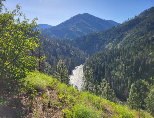
Area: Coeur d’Alene River Area of the Idaho Panhandle National Forest
Difficulty Rating: The trail is actually two trails, the Cedar Grove is a difficulty of 1 or 2 out of 5 and Trail #162 will evolve to a 3 out of 5, Moderate Difficulty.
Road Considerations: The last two miles of the road to the trail head may have some shallow water running across it and sometimes massive pot holes. There may be a bridge with damaged decking. A high clearance vehicle or Subaru type are recommended.
Total hiking miles: The trail is an out and back trail and affords options on how far to hike. If only viewing the cedar grove (a great reason to be there!), the round trip is < 1.5 miles. If one wants to continue to follow Eagle Creek to the trail’s termination at Road 270 (Clee Creek Bloom Peek Road) the one way distance is 5.3 miles with ~ 1850 feet of gain.
The Hike:
This area was burnt in a 2015 fire that left many of the trees above Eagle Creek dead. Many of the ancient cedars also burned, but survived the fire and are magnificent. The grove area is relatively flat and easy to hike. There are a number of bridges to cross and as you leave the grove, some ground water and a stream. You know for sure you are out of the grove when at about two miles, a bridge takes you from the west side of the creek to the east side. Be aware that brush does grow quickly along the trail in June. This year (2024) the Forest Service has had ICC crews in clearing blow downs and brushing. Additionally ITA spent three days also clearing trees and doing ~1.6 miles of brushing. While there is some tread damage due to blow downs, the brush is cleared and getting to the west to east creek crossing should be “easy”. Walking along and above Eagle Creek is beautiful and stopping for lunch or a snack is recommended. As you continue, more than half of the elevation gain is ahead before the trail levels off toward its end.
It needs to be emphasized that for the first time in a number of years the entire trail is open!
Places to camp along the way: There are dispersed camp sites in the Forest Service land prior to the parking lot and trail head; but, there is a lot of private land and camping must be on Forest Service property. Not far from the turnoff from Thompson Pass Rd is the East Fork of Lost Creek trail and more camping opportunities.
Things to consider: Dead fall/blow downs have been happening since the fire and will continue for some years to come. Beware of the tree danger and think twice about any creek crossing not on a bridge. The collapsed bridge does have a rotting and slippery log across the span and it is an iffy crossing.
Fun places to visit on your way in or out: Directions off of I-90 will take you up the North Fork of the Coeur d’Alene River where fishing and tubing/rafting is available. Close to I-90, the Snake Pit Restaurant is under new management and reopened.
More info about this hike: Check the Forest Service or All Trails for current trail reports.

Photo by Jim Manning