Our Trail Spotlight highlights day trips to multi-day hikes across Idaho. Trail conditions can change quickly- swollen rivers can become impassable, windstorms can knock trees down across trails, and snow can come earlier than expected. Please take these recommendations as a jumping off place and do additional research to understand current conditions and keep yourself safe if you choose to hike this trail. Physical guidebooks and maps are always good to have or check out some online resources like Alltrails.com for updated trail reports. If your trip is as awesome as you hope it will be, please share photos and feedback!

Photo by Leslie Anderson
Trail Spotlight: Mallard Larkins Pioneer Area from the Table Camp Trailhead – Mallard Peak Trail #11, Heart Pass Trail #65, Fawn Lake Trail #110, and Northbound Creek Trail #111
Recommended by: Leslie Anderson, ITA Crew Leader
Duration: Overnight backpacking
Area: Mallard Larkins Pioneer Area, St. Joe Ranger District, Idaho Panhandle National
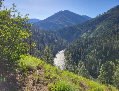
The remote Mallard Larkins Pioneer Area (MLPA) straddles the border between the St. Joe and Clearwater National Forests. The MLPA is roadless, has been recommended for designated wilderness and is essentially managed as wilderness. The “pioneer” designation recognizes its unique natural beauty and recreational values while providing extra protection for its resident wildlife and fisheries. It’s abundant streams flow into the Little North Fork of the Clearwater River. This area is rugged and isolated, offering beautiful vistas, serenity, and the opportunity to fish in 16 alpine lakes.
Difficulty Rating: 3 out of 5; longer distances with some steeper sections, yet only moderate elevation gains.
Road Considerations: For this hike, FS Road 201 provides access to the MLPA via a major trailhead at the Table Camp Campground. FS Road 201 is a ridge road west of and which roughly follows the contour of the St. Joe River. For Table Camp, the fastest route to FS Road 201 is the Beaver Creek Road 303, which is 82 miles from the beginning the St. Joe River Road/FH50 (off ID 3 just north of St. Maries). This is an incredibly scenic drive along a beautiful river, portions of which are federally designated Scenic or Wild & Scenic. The road is paved, although it does become narrower once FS 50 turns into NF-218/St. Joe River Road at 75 miles. The Beaver Creek Road, FS 303, is gravel, narrow and does climb; regardless, it can be done in an AWD auto with good clearance. It is about 8-9 miles to FS 201; turn left and continue 7-8 miles to Table Camp. As an alternative, one can take FS 509, Bluff Creek Road (about mile 69), off the St. Joe River Road/FH50 to access FS 201; this route involves more miles driving on gravel, yet is a better road than FS 303. This route also provides access to the Snow Peak TH, and views of Surveyor’s Ridge or the northern boundary for the MLPA.
Total hiking miles: Out and back mileage to Mallard Peak is 11.2; to Fawn Lake is 12.6; Northbound Lake is 16.6.
(Note: Mileages are from a wide pull-out about .25-mile further west from Table Camp, where it appears most hikers access the trail; however, there is a connector trail from the campground that skirts the north side of FS Road 201 before dropping back to cross the road at this pull-out.)
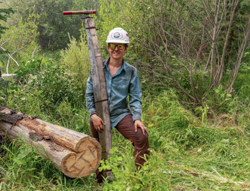
The Hike: In 2022, I was part of an ITA trail crew that was supported by a USFS packer; together, we cleared the trails described. During the week, we only encountered two small groups of backpackers.
We departed directly from Table Camp, following the trail north of FS201 before it crossed the road; there is room for about three vehicles to park near this large bend about ¼ mile past Table Camp, a time-saving option taken by others ahead of us. From FS 201, Mallard Peak Trail #11 roughly follows a ridge SW towards, then around Collins Peak. As Mallard Peak Trail #11 continues, breaks in the trees afford westerly views towards Mallard Peak. At 4 miles from FS 201 is a flat saddle, south of which lies the small, grassy shored Mallard Lake; this is a fine place to camp.
Another .3 miles further is the junction for the Fawn Lake Trail #110; the lake is reached 2 miles further along a fairly level and forested trail. It is a lovely lake partially surrounded with rocky walls. There is a nice campsite neat the outlet. Fawn Lake, at 12.6 miles RT, would be a nice 1–2-night trip.
If one stays on the Mallard Peak Trail #11, it begins to climb over the next mile to a high saddle south of Mallard Peak; enroute, one passes through a spectacular rocky hillside sprinkled with small shrubs and occasional trees. The Mallard Saddle is a trail junction with Nub Trail # 399 and the Heart Pass Trail #65. This area is a potential campsite as there is a small spring below the saddle on the east side. Highly recommended is a side trip to the end of Trail #11 to see the Mallard Peak lookout (elevation 6.870’) via a .5-mile, 500’ elevation gain jaunt up from the saddle. This lookout is being restored to its 1929 configuration by dedicated volunteers. It sits on a precarious perch with stunning views.
Continuing westerly from the saddle, the trail becomes the Heart Pass Trail #65. This trail stays high, roughly following the ridge between Mallard Peak and Larkins Peak. It meanders through forest, brush and open hillsides. At 1.4 miles west of the Mallard Peak saddle is a junction to Skyland Lake (Trail #25) at another flat and shaded saddle. There is a good spring on Heart Pass Trail #65 just a bit west of the Skyland junction; continue another .7 mile to the junction for Northbound Lake. The Northbound Creek Trail #111 drops via some gradual switchbacks to this stunning lake in .25 mile. There is a large campsite on the NE side of the lake. If lucky, one may spot a moose or mountain goat. Northbound Lake is a worthy backpacking destination.

Photo by Joanie Fauci

Photo by Leslie Anderson
Places to camp along the way: Mallard Lake, Fawn Lake, Mallard Saddle, Northbound Lake.
Things to consider: Heart Lake is the largest of the alpine lakes found in the MLPA and the most popular destination for backpackers. While most folks access it via the south on Smith Ridge Trail #240, it can also be attained by continuing another 1.1 mile west of the Northbound Creek Trail #111 junction on Heart Pass trail #65 to the turnoff to Heart Lake; Heart Lake would be an 18.5-mile RT hike via this route and include less elevation gain than via Smith Ridge. Crag, Larkins and other small lakes lie to the NW of Heart Lake.
Maps of the MLPA show many loop options, either from near Table Camp or the end of FS Road 201 at Sawtooth Saddle. Caution is needed as several of these routes are quite steep and brushy, and not as frequently maintained.
The MLPA can also be accessed via the southern side within the Clearwater National Forest; e.g., Smith Ridge, Isabelle Creek, Black Mountain or the Nub TH’s.
This area does have the potential for hot days that can produce quick moving thunderstorms; there is rocky terrain in places; and there exists the possibility for exposure to bees and mosquitoes. On the flip side, are the delicious huckleberries (during season).
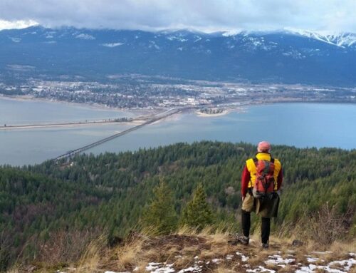
Fun places to visit on your way in or out: Red Ives Historic Ranger Station (information center and rental cabin), Surveyor’s Ridge Lookout (rental), Avery Store, Snow Peak (hike and WMA-https://idfg.idaho.gov/visit/wma/snow-peak), and the Wild section of the “Shadowy” St. Joe River.
More info about this hike: There isn’t a lot of information online about hiking in the MLPA, yet these blogs and trail reports can provide some background.
https://www.summitpost.org/mallard-larkins-pioneer-area/288752
http://nhlr.org/lookouts/us/id/mallard-peak-lookout/
https://clearwatertrekker.com/trekking-smith-ridge-trail-to-heart-lake/
https://www.alltrails.com/trail/us/idaho/mallard-larkins-loop
https://www.fs.usda.gov/recarea/ipnf/recreation/recarea/?recid=82518&actid=42
Upcoming Projects: Check out ITA’s 2025 Heart Lake and St. Joe River volunteer projects to visit this incredible area!

Photo by Leslie Anderson

Photo by Leslie Anderson

Photo by Leslie Anderson

Great summary of an amazing place. And awesome pics! I proposed to my wife in MLPA in 2016 so it will always be a favorite. Thanks for all you do to keep it accessible!