Our Trail Spotlight highlights day trips to multi-day hikes across Idaho. Trail conditions can change quickly- swollen rivers can become impassable, windstorms can knock trees down across trails, and snow can come earlier than expected. Please take these recommendations as a jumping off place and do additional research to understand current conditions and keep yourself safe if you choose to hike this trail. Physical guidebooks and maps are always good to have or check out some online resources like Alltrails.com for updated trail reports. If your trip is as awesome as you hope it will be, please share photos and feedback!
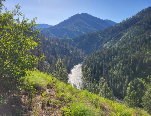
Trail Spotlight: Deep Creek Trail #219
Recommended by: Melanie Vining, ITA Executive Director
Duration: Day Hike
Area: Hells Canyon Wilderness
Difficulty Rating: 3, with steady climbing or descending and little flat ground, this hike is more difficult than some, but the gentle grade of most of the trail makes climbing less arduous than steeper trails.
Road Considerations: Paved road all the way from Cambridge, Idaho. Take Highway 71 to Brownlee Dam; after crossing to the Oregon side of Hells Canyon, the road is maintained by Idaho Power but is still a good, two-lane paved road, much like the highway. Can be icy in winter. Large, gravel parking lot at the trailhead makes this drive, and parking, suitable for any car or truck.
Total hiking miles: 8.4 miles out and back from the trailhead to the Deep Creek crossing. Not recommended to go further because of current trail conditions.
The Hike: The Deep Creek Trail #219 is an ideal early spring hike, sure to help get the legs back in shape for trail season while offering incredible views of Hells Canyon as one climbs. Starting just upstream of the Hells Canyon Dam and Visitor Center (perfect post-hike side trip!), the trail parking is adjacent to the main road and, while not a developed site, usually has a porta potty to accommodate spring traffic in the canyon.
The trail starts out at the Eagle Bar trailhead, at approximately 1800 feet elevation, on an old roadbed. Long since grown in with shrubs and native grasses one doesn’t really feel like they are hiking on a road. The upside of this is it makes for a nice grade while consistently gaining elevation from the canyon floor.
The trail makes several switchbacks before heading north toward the actual Deep Creek drainage, continuing to climb. At approximately 3.1 miles, the trail turns east into the Deep Creek drainage and loses elevation as it drops 1.1 miles to cross Deep Creek at the junction with the Oxbow Creek Trail #215. Keep this in mind if hiking for the first time after a winter off; the hike back to the car is not all downhill.
At this point, unless one is seeking adventure that involves crouching through thick brush and over downfall, it is advised to have a snack, call it a day hike, and head back to the car. This trail is in good shape other than some brush here and there for most of this 4.2-mile/8.4 mile round trip first segment, but deteriorates quickly at the creek crossing (Future ITA project? Maybe!). In addition, Deep Creek can be high, swift, and dangerous to cross during peak runoff months, though in late winter or early spring water should still be low, making for safe crossing.
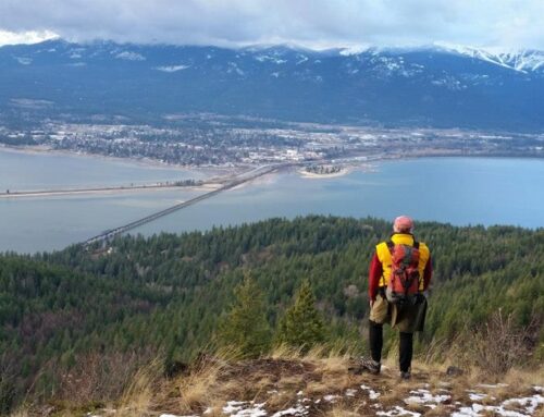
Get out of winter’s grip this year and check out Hells Canyon! This trail is a great way to stretch the legs on a snow-free surface and catch views of wintering elk and deer (please be respectful of their space as their energy reserves are limited in the winter) and even mountain goats perched on the cliffs above Deep Creek and Hells Canyon Dam. Views abound, and in March you can catch the first wildflowers of spring along the trail.
Places to camp along the way: There are several developed campgrounds in Hells Canyon, including at Oxbow Dam and Hells Canyon Park Campground, but check on availability of campground services if you choose to go in the winter months. Big Bar is a large, dispersed campsite about thirty minutes south of the Deep Creek trail and is accessible all year round. Bring your own water, but there are vault toilets available.
Things to consider: Please check road and weather conditions before making this trip. While the bottom of the canyon is typically snow free, one can find themselves in winter conditions quickly as they gain elevation. Pack to be prepared.
Fun places to visit on your way in or out: On the way home, grab a hot drink or a burger at the Gateway Store or drive a little further back to Cambridge for several awesome local eateries. These small businesses rely on tourism, and a friendly visitor during the slow season is welcome and appreciated.

Photo by Melanie Vining

Photo by Kelly Hewes


Leave A Comment