Our Trail Spotlight highlights day trips to multi-day hikes across Idaho. Trail conditions can change quickly- swollen rivers can become impassable, windstorms can knock trees down across trails, and snow can come earlier than expected. Please take these recommendations as a jumping off place and do additional research to understand current conditions and keep yourself safe if you choose to hike this trail. Physical guidebooks and maps are always good to have or check out some online resources like Alltrails.com for updated trail reports. If your trip is as awesome as hope it will be, please share photos and feedback!

photo by Clay Jacobson
Recommended by: Tom Dabrowski, ITA Crew Leader and member of ITA’s Board of Directors
Duration: Two to four days, depending on side trips
Area: Salmo Priest Wilderness and adjacent unprotected lands
Difficulty Rating: 3 – This 18 mile loop has ups and downs that add to about 4,000’ in elevation change. There is one river crossing that can be difficult before mid July.
Road Considerations: From Priest River, Idaho drive north on paved Idaho 57 about 37 miles to the small village of Nordman. Bear left on dirt/gravel Forest Service roads towards Stagger Inn Campground then turn left on the Pass Creek Pass road, go over the divide and at the junction with USFS Road 2220 turn right and drive towards Salmo Mountain and the trailhead. Total distance from Nordman is about 40 miles, all on dirt roads that are passable with a passenger car with good clearance. It’s a beautiful drive with great views along the way. The trail head coordinates are 48.95645N, 117.08083W, at 5907’ elevation
Total hiking miles: It is approximately 18 miles to hike the main loop, with opportunities to take side trips at several places.
The Hike
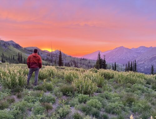
This hike is about as far north as you can go in Idaho and actually starts in the NE corner of Washington State. The recommended way to do this loop is clockwise from the trailhead. You’ll start on Trail 506 at elevation 5907’ and drop in 3 ½ miles to a crossing of the pretty Salmo River at 4,100’. Turn east (right) and head up about 2 miles to an unsigned trail junction ion the right to drop down to another river crossing and a short uphill pitch to a nice camp at the messy remains of the historic Salmo Cabin.
Back on the main trail, head up the valley about 3 ½ miles to the last reliable water and an OK camp. Or, better yet, load up on water and go another mile up to the ridge top and a nice camp at 6,300’ right on the trail. This is a good spot to take a side trip to the summit of Snowy Top Mountain (7,572’) to the north. There is no trail up there and good navigation skills are required. If you are not sure if this is for you, there is another summit further south that you can go up. See below.
From the ridge camp, continue south on what is now the Shedroof Divide Trail #512, which heads many miles all the way down to the Pass Creek Pass road you drove in on. But we’ll turn off of 512 before we get that far south.
After about 1 mile, find a side trail to the right (west) up Little Snowy Top. It’s about 1 mile to the top and offers great views and a much easier ascent than Snow Top that was mentioned above. The historic lookout up here burned down a while back but the trip to the top is well worth the effort.
After returning from Little Snowy Top, continue on south 512. You’ll soon pass a trail on the left that used to head all the way down to the Priest River 3,400’ below but a landslide on the very steep hills totally wiped out that trail. About 3 miles further on, you’ll go through a pass, head down the other side and come to the only reliable water along this stretch. There are several camps here and make a good place to stop for the day and explore the country nearby.
Another 2 miles on the very scenic Shedroof Divide Trail #512 will bring you to a low pass and Trail #535 on the right. Take that trail for about 5 miles back to your vehicle at the trailhead.
Places to camp along the way: After the Salmo River crossing on your first day, there are lots of places to camp as you hike up the north side of the river. The old Salmo Cabin site mentioned above is nice because you can look at the remains of the collapsed buildings there. Another 3 ½ miles up the Salmo River and about ¾ miles below the divide where you get to trail 512, there is a place to camp with the last water for many miles. Tank up here. The next water is about 5 or 6 miles away. That next water source has a couple of tent sites and will probably be your last camp.
Things to consider: This loop may be blocked by snow until early July. The flowers in July can be really impressive, especially on the divide, but the mosquitoes can be bad along the river. The best time to do this hike may be in the fall when the bugs are gone and the river provides a refreshing dip.
If you decide to try to go up Snowy Top Mountain make sure you have good maps and a way to communicate with the outside world in case of a problem. You’ll be just ½ mile south of the border with Canada. There is no cell service anywhere along the whole loop.
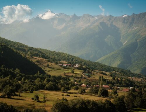
Fun places to visit on your way in or out: If this is your first foray way up here, stop at the US Forest Service station across from the big airstrip south of Nordman. The nice folks there have booklets describing short hikes including one through the big cedar trees near Stagger Inn campground. The café in Nordman has good food and is well worth a visit. For a change of scenery and a chance to see different country, go back home via Sullivan Lake in Washington. You can do this by continuing straight ahead when you reach the Pass Creek Pass road on the left (this is the road you took on the way in) as you leave the high country.

Photo by Clay Jacobson

photo by Clay Jacobson

photo by Clay Jacobson

photo by Clay Jacobson

photo by Clay Jacobson
Nice report. We are going soon. Wondering if you need a bear canister?
Thanks
Ali
You can use a canister or do a bear hang. There are griz and black bears in this area. Water is hard find on the ridge. Great hike!