Our Trail Spotlight highlights day trips to multi-day hikes across Idaho. Trail conditions can change quickly- swollen rivers can become impassable, windstorms can knock trees down across trails, and snow can come earlier than expected. Please take these recommendations as a jumping off place and do additional research to understand current conditions and keep yourself safe if you choose to hike this trail. Physical guidebooks and maps are always good to have or check out some online resources like Alltrails.com for updated trail reports. If your trip is as awesome as you hope it will be, please share photos and feedback!

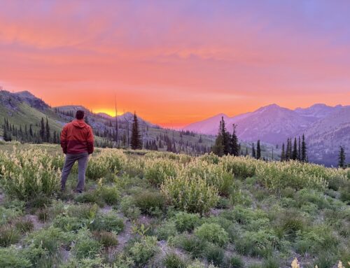
photo by Greg Hart
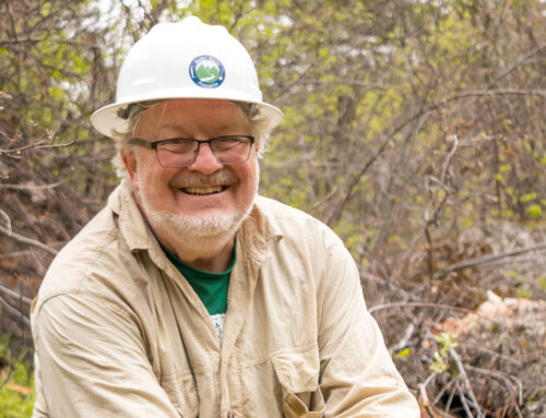
Recommended by: Greg Hart, Crew Leader
Duration: Day hike
Area: Boise River Wildlife Management Area, Boise Front Area of Critical Environmental Concern, Boise National Forest– Mountain Home Ranger District
Difficulty Rating: 3 out of 5- sections of trail are steep and exposed to sun, tread is rocky and uneven in places
Road Considerations: Paved road to small, dirt trailhead
Total hiking miles: 9.6 miles, out and back with optional loop at top
The Hike: The trail to Adelmann Mine is one of the most well-known and popular hikes in Boise for obvious reasons – it’s a short drive, it’s not too long or difficult, the scenery is superb, and the destination is one of the most unique you’ll find in the whole state. What most hikers don’t know is that beyond the eerie, intriguing premises of the abandoned gold mining operation, the trail continues, offering an exceptional hike to the summit of Lucky Peak.
At the trailhead, squeeze through the narrow chicane and start walking up the gravel road through the Boise River WMA depot. Be courteous to any employees, especially if they’re moving heavy machinery around. The BRWMA spans east-west from Arrowrock Dam to Boise proper and all the way down to the Danskin Mountains at its southern border, conserving 36,000 acres of critical winter habitat for thousands of mule deer and elk. To maintain this safe haven for cervine animals, all dogs must be leashed.
The first mile is relatively nondescript, rising about 400 feet through tall grass and sagebrush. In 2023, groundwater from the long, wet winter and rain from near-constant thunderstorms kept the grass lush and vibrant through June, but this section of the foothills tends to dry out rapidly in average summer heat. After one mile, the road crosses over two streams and begins ascending the rocky hillsides quite steeply. You’ll wonder how industrial vehicles from a century ago could ever make it up such a slope.
At 1.8 miles, you’ll crest a hill and get a first glance at the main mine building nestled in the gulch ahead. Starting here, the grade gradually tapers off – the steepest part is over. At 2.1 miles, you’ll arrive at an intersection where the spur to the mine splinters from the main trail, and you can choose whether to visit it now, on the way down, or both. Whichever you prefer, it’s a flat, painless quarter mile to the mine with a minor creek crossing that is typically dry by midsummer. This is a great spot to rest, hydrate, and eat a snack.
To continue on to Lucky Peak, head back the way you came to the intersection. Then, instead of going downhill to the left, continue up and to the right on the trail that climbs towards the gate on the ridge. After the gate, the trail hairpins and continues climbing up the side of the hill. The quality of the surface starts to diminish from dirt road to two track. There’s occasional shade from huge snowbrush plants and the quality and quantity of wildflowers both increase. At mile 3.4, you’ll see the mine from above before turning the corner and starting a healthy climb into the pine forest on Lucky Peak’s east slopes.
After 3.5 miles, the trail enters a narrow gulch and becomes much rockier before leveling out in a small meadow. Another small ascent leads to the edge of Lucky Peak’s east ridge, where the forest becomes considerably thicker. Here, the trail widens again to a forest road and flattens out almost completely for just over a half-mile to a gated intersection with the Shaw Mountain Road Trail of the Ridge to Rivers system. The gate is locked to vehicle travel, but there’s a chicane tucked away in the bushes on the left. Hang a left up the rocky trail for the final push to the peak.
At mile 4.8, you’ll reach a false summit as the Intermountain Bird Observatory camp comes into view ahead of you. The trail then curves up to the 5,904-foot summit of Lucky Peak, which has several survey markers and a radio tower. The views of Boise and the Treasure Valley are spectacular from here, especially in the evening when the sun starts to set. If you bring a lunch, this is the spot to eat it.
On the return leg, there is a superb single-track trail that isn’t listed on any other hiking or mountain biking site. To find it, retrace your steps to the false summit opposite the IBO camp. When the trail turns north, look for two wooden steps on the right (east) – turn onto this minor trail, which travels up and over a small hill before descending into a wildflower-ridden section of forest filled with serenading songbirds. While this route is a little overgrown, it makes up for it with serenity and beauty. Once you reach the intersection with the main trail, head south and downhill back to the mine and the trailhead.
Things to consider: This is not a trail I’d recommend for midsummer, as the lower miles are dusty, steep, and completely shadeless – the kind of environment more suited for lizards and rattlesnakes than hikers. This area is also prone to Mormon cricket swarms in the June and July. If bugs aren’t your thing, check recent AllTrails reviews before setting off. If you do want to hike it in the summer, go early and bring plenty of water, as there are no reliable water sources along the way.
When the weather is appropriate, the trail to Adelmann Mine can be busy. With over 1,000 reviews on AllTrails, this is one of the most popular hikes in the Treasure Valley. While the number of people doesn’t pose a huge issue, the limited amount of parking does. You may have to park on the shoulder of Highway 21 and walk to the trailhead. On the trail, crowds thin significantly once you leave the abandoned mine buildings and continue ascending towards Lucky Peak.
If researchers are present at the Intermountain Bird Observatory station, be courteous, especially when passing through their camp. As always, be respectful to other trail users and Leave No Trace!
Fun places to visit on your way in or out: After the hike, stop for a burger and fries at Bad Boy Burgers or a sandwich at Fat Guy’s Fresh Deli, both located near the intersection of Highway 21 and Interstate 84 in southeast Boise. I live down the road and frequent both places, which are equally effective at replacing all of the calories spent hiking to Lucky Peak (and then some).
More info about this hike: There is an AllTrails entry for this trail, in addition to a post I wrote for my personal blog this year (I may have plagiarized myself pretty heavily here). Feel free to reach out to me via the social media accounts linked in my blog if you’d like more information on this trail, or any other I’ve hiked.

Photo by Greg Hart

Photo by Greg Hart

photo by Greg Hart

photo by Greg Hart
Leave A Comment