Our Trail Spotlight highlights day trips to multi-day hikes across Idaho. Trail conditions can change quickly- swollen rivers can become impassable, windstorms can knock trees down across trails, and snow can come earlier than expected. Please take these recommendations as a jumping off place and do additional research to understand current conditions and keep yourself safe if you choose to hike this trail. Physical guidebooks and maps are always good to have or check out some online resources like Alltrails.com for updated trail reports. If your trip is as awesome as you hope it will be, please share photos and feedback!

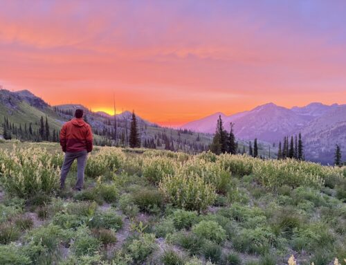
Photo curtesy Leslie Anderson
Recommended by: Leslie Anderson, ITA Crew Leader
Duration: Day Hike, with options for a backpacking loop (see “Things to Consider”).
Area: Nez Perce Clearwater National Forest and the Selway Bitterroot Wilderness
Difficulty Rating: 4 out of 5- This is a nice trail, yet does have a fairly consistent uphill pitch. Elevation gain is 2,500’ over the 3.6 miles from the trailhead to the saddle; the next mile gains nearly another 800’, to 5,200’.
Road Considerations: The Wilderness Gateway Campground roads are all paved, and are accessed off US Highway 12. Trailhead is beyond the four campground loops, but before the outfitter headquarters. See https://www.fs.usda.gov/recarea/nezperceclearwater/recarea/?recid=80725.
Total hiking miles: An out and back trail; 3.6 to wilderness boundary; trail cleared to 4.5 miles. Total distance ranges from 7.2 to 9 miles.
The Hike:
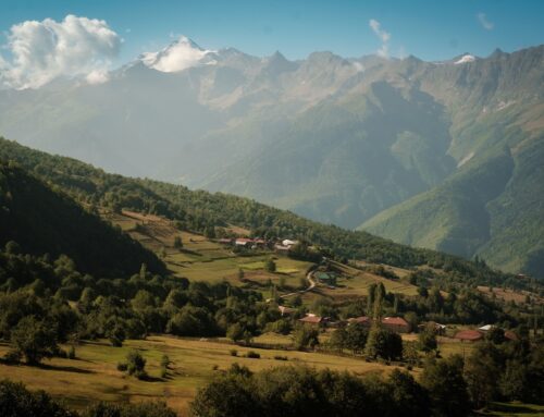
This hike offers solitude, beauty, an opportunity to hike a section of the Idaho Centennial Trail, and provides access to the Selway Bitterroot Wilderness. Trail 220 is accessed via the Wilderness Gateway Trailhead which is located just uphill from the D loop of the Wilderness Gateway Campground; signage shows Lochsa Peak and Lottie Lake. This trail winds through a lovely forest canopy with areas of switchbacks and long straight stretches. The trail does climb fairly consistently, yet is mostly shaded. This area receives rainfall levels which support the growth of thick underbrush and abundant flowering plants in less shady areas. Occasional views are primarily of the Boulder Creek drainage. Interestingly, there is no official trail to Lochsa Peak (elevation 4,882’), rather only a small, unofficial path that leaves Trail 220 just before the saddle SSE of the peak. The saddle lies at ~4,700’ and 3.6 miles from the TH, and offers views to the east. Trail 243, to Old Man Point, branches to the west off Trail 220 at the saddle. Just beyond this junction is the official boundary marker for the Selway Bitterroot Wilderness. Please note this sign was damaged and only part of it was still attached to a tree in August 2023. From here, Trail 220 proceeds through a tall forest with a fairly open floor until it soon reaches a narrow ridge that is covered with tall brush, a landscape recovering from an older burn and one that offers views to the west. During season, huckleberries are abundant in this section. At mile 4.5, the trail re-enters the forest; this is a good turn-around point for those wishing to hike beyond the saddle.
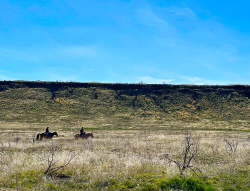
Places to camp along the way: Wilderness Gateway Campground offers a large number of camping options, many reservable via Recreation.gov. On the trail, the first flat area was at the saddle. There were a surprising number of small streams along the trail, yet none noted at the saddle.
Things to consider: Trail 220 doesn’t see a lot of traffic, as most folks are hiking Trail 211, Boulder Creek, which provides access to popular Stanley Hot Springs. Those more adventurous could hike a big loop (about 20 miles total) from the Wilderness Gateway Trailhead and also get to Stanley Hot Springs (at about 14.5 miles). From the wilderness boundary, Trail 220 travels a series of ridges over Cantaloupe Peak (elevation ~ 6,100’) and Huckleberry Butte (elevation 6,686’) then slopes down towards Lottie Lake and the Seven Lakes Basin. Trail 221/2210 to Stanley Hot Springs leaves Trail 220 at 10.1 miles; while a bit prior to Lottie Lake, perhaps the lake would provide a good campsite? Trail 221/2210 drops about 1,500’ to the hot springs, then continues on to connect with Trail 211 north of the hot springs. Trail 211 returns hikers to the Wilderness Gateway Campground at the Boulder Creek Trailhead. Trails 220 and 221/2210 within the Selway Bitterroot Wilderness have not been recently cleared, aside from about one mile beyond the boundary at the Lochsa Peak Saddle, which was cleared by the ITA August 2023; conditions could be challenging yet rewarding.
Fun places to visit on your way in or out: The Lochsa Historical Ranger Station (https://www.fs.usda.gov/recarea/nezperceclearwater/recarea/?recid=80263) is well worth a visit, as would be Weir Creek (https://www.ultimatehotspringsguide.com/weir-creek-hot-springs.html) or Jerry Johnson Hot Springs (https://www.idahohotsprings.com/destinations/jerry_johnson/) with trailhead access off Hwy 12.
More info about this hike: This hike is not on AllTrails; however, you can research this and other adjacent hiking options at the following links.
https://www.trailforks.com/trails/ict-bitterroot-wilderness-lochsa-peak/
https://parksandrecreation.idaho.gov/activities/hiking/centennial-trail/
https://www.alltrails.com/trail/us/idaho/seven-lakes-trail-to-maude-lake-to-lottie-lakes-loop
https://www.ultimatehotspringsguide.com/stanley-hot-springs.html

Photo curtesy Trey Dozier

Photo curtesy Aubrianna Pate

Photo curtesy Leslie Anderson

Photo curtesy Leslie Anderson
this hike seems perfect for someone who enjoys a challenge and beautiful scenery. The fact that it offers solitude is a big plus for me, and the chance to hike a section of the Idaho Centennial Trail is exciting too.
I would recommend doing some additional research before you go, such as checking the current trail conditions and making sure you have the proper gear.
Hiked this as part of a bigger loop into the Selway Crags. Loved this section of trail! Camped the night in a lovely spot shaded by big cedars just off the saddle (~100′ down Old Man Point trail). There’s a great water source at Big Stew Creek about 1/2 mile down from the saddle along Old Man Point trail. It’s a gorgeous stream, very lush. Felt like walking into the A/C when I got there.
Trail was great until Cantaloupe Peak where there was blow down through a burned area. It really wasn’t bad though. Also consistent blow down on a stretch past Huckleberry Butte, around halfway to Lottie Lake.
Also, I would not recommend the Rock Creek Lake trail 2210 down to Stanley Hot Springs. Was planning to hike it at the end but didnt because it looked totally bombed out from a wildfire, matchsticks everywhere (I could see the ridge while coming from Huckleberry Butte). Instead took Surprise Creek down to Boulder Creek and it was wonderful trail conditions.
In 1961 and ’62, I worked on Forest Service crew that blasted out more than a mile of trail with many rocky bluffs along Boulder Creek 8 miles or so up from trailhead (we stayed in Horse Camp cabin). This bypassed Boulder Pass, a steep and dangerous trail section backcountry packers hated. Led by crew boss Jim Davis, we burned through many cases of dynamite (and ate whole bunch of cutthroat from the creek) on that project. It wasn’t considered wilderness yet, so we were allowed to use 1-yard bellydump to haul dirt to lay a trailbed through the blasted rock. Called our crew “Piss Ant Construction Co.).