Our Trail Spotlight highlights day trips to multi-day hikes across Idaho. Trail conditions can change quickly- swollen rivers can become impassable, windstorms can knock trees down across trails, and snow can come earlier than expected. Please take these recommendations as a jumping off place and do additional research to understand current conditions and keep yourself safe if you choose to hike this trail. Physical guidebooks and maps are always good to have or check out some online resources like Alltrails.com for updated trail reports. If your trip is as awesome as you hope it will be, please share photos and feedback!

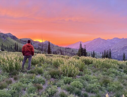
Photo by Stuart Tan
Duration: Multi-night Backpacking
Area: Frank Church-River of No Return Wilderness/Payette National Forest
Difficulty Rating: 4 out of 5- Although the trail does not have many long steep sections, it does rise and fall regularly enough to get your heart rate up. When the weather heats up some areas of the trail provide little or no shade. It can also become very cold or wet in a few hours. Creek crossings can be difficult as well when the water is high in the spring. Although the trail is maintained regularly there are areas that are unstable (rocky sections) making the trail hazardous without sure footing. Because of these factors and the remoteness of this trail, it is recommended for experienced backpackers.
Total hiking miles: 26 miles
Located in the Payette National Forest in The Frank Church-River of No Return Wilderness, this remote trail boasts beautiful views and a true wilderness. Massive cliff-side caves and waterfalls cascading down the craggy cliffs are just some of the spectacular sights awaiting you on this trail. You will also find signs of the Shoshone Sheepeater tribe, which was driven from the area in the late 1800s by the United States Army.
Starting at the end of Big Creek and Smith Creek Roads, the trail runs east on the north side of the Salmon River in the canyon. The trail covers over thirty-six miles of rugged backcountry on its way to meet up with the Middle Fork River Trail #6044 and Waterfall Trail #6045 at the Middle Fork of the Salmon River.
Along the way, hikers will cross many other trails: Ramey Ridge Trail #006, Cold Meadow Trail #002, Lookout Mountain Ridge Trail #061, Coxey Creek Trail #050, Cabin Creek Trail #4102, Canyon Creek Trail, Rush Creek Point Trail #138, Coyote Spring Cow Creek Trail #044, Big Creek Ridge Trail #055, Goat Creek Trail #053, Soldier Bar Trail #054, Waterfall Trail #6045 and Middle Fork River Trail #6044.
Getting there:
The trailhead is located at the north end of the Big Creek airstrip. A four-unit campground at the south end of the airstrip offers a good staging place to access the Frank Church-River of No Return Wilderness. It is popular with pilots camping overnight in Big Creek. The campground is also near the Forest Service’s Big Creek Work Center. Facilities include an accessible toilet and drinking water. It is pack-in/pack-out, with no hook-ups. The campground is not open until July, so any earlier the only access to the trail for hiking is via the airstrip.
Located twenty-one miles to the west of the Big Creek Trailhead and fourteen miles east of the Big Creek Trail’s junction at the Middle Fork of the Salmon River, Cabin Creek airstrip is also a popular access point to this trail. This airstrip is about a thirty-minute flight from McCall, Idaho. The flight is spectacular, passing over mountain lakes, rugged canyons, snow-capped mountains, and several remote towns. Elk and other wildlife can be seen from the air below the snowline line in the spring.

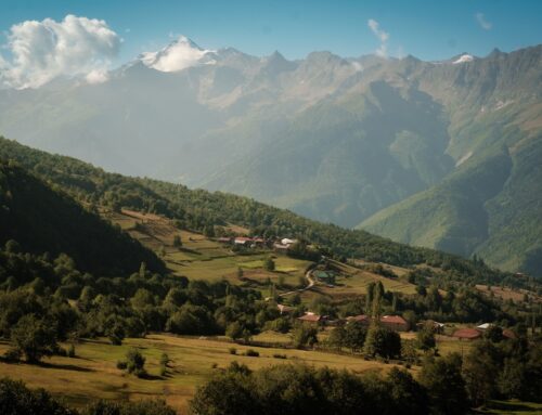
Photo by Cindy Walker

Photo by Cindy Walker
The Hike:
At the base of the Cabin Creek airstrip, the Payette National Forest Service has a cabin used by Forest Service personnel (not open to the public). From the cabin, it is about another half a mile to Big Creek Trail.
This spotlight is primarily about the trail heading east from Cabin Creek. The trail east is well established and easily navigable on foot, following beside Big Creek for just over fourteen miles. The trail is used by hikers, hunters, and riders on horseback, but because access is so remote, you are very unlikely to encounter other people (aside from the caretaker at Taylor Ranch).
Depending on the snowpack, the river can run high in the spring, causing the creeks running into Big Creek to swell as well. The terrain is undulating, with mixed surfaces—from rock covered cliffs in the canyon to wide meadows at lower elevations. Though some areas are narrow in the rocky canyon a few miles before the Middle Fork, the trail is in good condition for hiking. Trail elevation ranges from 5,435 ft to 3,426 ft. The maximum grade is fifteen percent, with an overall decline in elevation to the Middle Fork.
The canyon trail east from Cabin Creek starts out wide and is easily navigable, but becomes rocky and narrow over the last five miles. Evidence of rock slides makes the terrain a little more difficult to navigate due to loose rock. In order to keep the trail accessible to foot traffic and stock, brushwork and other repairs are completed yearly after the snow melts in the spring. Treefall is usually minimal, and the tread is well established.
There are several meadows where hikers can camp. About four miles down the trail, Browns Basin is one of the closest group camp sites to Cabin Creek. At six miles from Cabin Creek, Lobaur Basin has easy access to water, and is another great area to set up camp.
Taylor Ranch Research Station, owned by the University of Idaho, can be seen across the river about seven miles in. It is occupied year round, and frequently in use by research students.
At .7 miles past Taylor Ranch, you will hit a bend in the river with a very nice open area to set up camp. Here you will find the remains of a Sheepeater village—a Shoshone tribe who inhabited this area before being driven out by the United States Army in 1879. The Sheepeaters lived in semi-subterranean pit houses, and the pits are still evident today as you continue along the trail. Evidence of their villages also includes pictographs and large stone mortars or granaries.
About nine miles in, Goat Creek may be the last area that is amenable to setting up camp before hitting the gorge, which is a narrow rocky canyon. The spring of 2024 had a relatively low runoff, so this creek and the river’s edge were easily navigable, but in other years the river can run higher, making navigation difficult. Cougar Creek, a few miles from Goat Creek, also runs high some years, so take care crossing. Later in the season, creeks running into Big Creek will be less of an issue. While access to water is readily available, a water filter is recommended.
Continuing along the canyon, evidence of rock slides from the winter snow obscures the tread, and narrows it in sections. As a cautionary tale, the caretaker at Taylor Ranch tells of several mules that have gone over the cliff’s edge over the last few years; look where your feet land and be sure the trail ahead is clear!
The weather can change quickly in the canyon. Be prepared for all types of weather in the spring and for hot days later in the season.
Plenty of wildlife will be in evidence along this fourteen mile stretch, including elk, coyote, bighorn sheep, and bear. Spring brings a lot of ticks and a few snakes, but very few mosquitoes or horse flies (those become more of a problem later in the season).
More info about this hike: Check out this blog by an ITA volunteer who worked with a crew headed west on Big Creek: https://davefaitlemonde.com/2021/04/26/cabin-creek-big-creek-expedition-day-two-frank-church-wilderness-idaho/

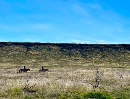
Photo by Taylor Izzard

Photo by Stuart Tan

Photo by Stuart Tan
Leave A Comment