Our Trail Spotlight highlights day trips to multi-day hikes across Idaho. Trail conditions can change quickly- swollen rivers can become impassable, windstorms can knock trees down across trails, and snow can come earlier than expected. Please take these recommendations as a jumping off place and do additional research to understand current conditions and keep yourself safe if you choose to hike this trail. Physical guidebooks and maps are always good to have or check out some online resources like Alltrails.com for updated trail reports. If your trip is as awesome as you hope it will be, please share photos and feedback!

Photo by Herbert Klein
Title: Trail Spotlight: Beetop/Roundtop Trail 120
Recommended by: Ken Dueis (ITA Volunter/Crew Leader)
Duration: Overnight Backpacking
Area: Idaho Panhandle National Forest
Difficulty Rating: Most of this trail from Trestle Peak TH on the north end, to the Beetop spur (15 miles) is a 2. From this junction, the trail drops steeply for about 2.4 miles, making this section a 4, before flattening out for the final 2 mile stretch to the south TH. Trail is not technical but expect numerous deadfall. Suggest hiking from north to south to avoid the steep elevation gain encountered coming from the south.
Road Considerations: Roads to both TH’s are gravel but normally suitable for most vehicles.
Total hiking miles: About 21 (per USFS).
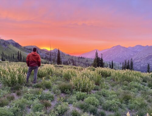
The Hike: Trail 120 leaves the Trestle Peak TH at about 5000’ of elevation. The hike begins relatively flat but after the first switchback the grade steepens moderately. Over the next mile or so the route passes in and out of wooded areas before becoming mostly open country, gradually moving up the ridge. Much of the terrain is now burn scar and the trail gains the ridge. After about 3.2 miles, watch for a lightly used spur trail to the left that leads up to Trestle Peak and fantastic views in all directions.
Drop back down the short spur to the ridge trail and proceed south. The trail remains mostly on the ridge top and moves in and out of timber and more burn scars. Another 3.5 miles and Roundtop looms on your right. Take the time to take this short but steep spur to the summit of the mountain for spectacular views of Lake Pend Oreille to the west as well as the rugged Montana Cabinets to the east. At this summit, remains of an historic fire lookout are evident.
Once again drop back to the main trail and continue south a short distance to the best camping site along this trail where Wellington Road from the east and Strong Creek ATV trail from the west converge in the saddle. You will likely have the campsite to yourself as Wellington Road vehicle access is currently unavailable. There is no water available here.
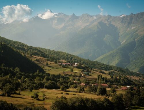
From this point heading south the trail leads through some timber but then breaks out into open meadow and gorgeous views of the Green Monarchs to the south, southwest. Watch for huckleberries along this section in late summer! On a clear day this portion of the trail is unparalleled in North Idaho.
Continue along the ridge southeast. At times the trail reveals sweeping views of the Lightning Creek drainage to the east. Pass just below Cougar Peak then watch for a trail junction. Stay right to remain on Trail 120. The fork to the left heads steeply down to Porcupine Lake, a great side trip if you have an extra day.
At about the 15 mile mark, watch for another junction. To the left is the spur to Beetop Mountain and to the right is the main 120 trail. Trail 63 to the top of Beetop is about 2 miles.
To complete the main route, head trail right at the junction. The tread will descend steeply for the next 2.4 miles, leading quickly down the ridge overlooking Lightning Creek. At the bottom of these switchbacks the trail becomes easier and passes through heavy timber and over several small bridges crossing seasonal streams. The last 3/4 miles of trail is very easy as it leads down an old roadbed towards the southern trailhead. Shortly before the TH is an impressive USFS footbridge that crosses Spring Creek which may run most of the hiking season.
Congratulate yourself on completing one of the great sections of the Idaho Centennial Trail.

Photo by Herbert Klein

Photo by Herbert Klein

Photo by Chloe Gallagher
Places to camp along the way: Most of this trail is along or just below a ridge line. There are lots of campsite possibilities but stay below the ridge. There is a large camping area just south of Roundtop, where the trail is intersected by Wellington Road. Note: This road is not currently available to access Trail 120 since the flood in December, 2025.
Things to consider: As this is mostly a high and dry, ridge line trail, expect lots of sun during the summer hiking season. Be prepared with sun screen, sun glasses, hat and long sleeve sun shirt. There are no water sources on the ridge so bring plenty of water. Spring Creek near the south TH may be a water source into the early summer. Mosquitos may be present and expect ticks. Trekking poles are a good idea for descending the steep section coming down to the south TH. Again, expect to navigate several deadfall along the way.
Fun places to visit on your way in or out: Great places to refuel post hike are in nearby Hope, ID. B’s Beacon and The Old Ice House Pizzaria will have you covered and both offer outdoor seating overlooking Lake Pend Oreille.
Upcoming Trail Project: support this great trail by volunteering on our Beetop Roundtop Project!

Photo by Ken Dueis

Photo by Herbert Klein

Photo by Howard Shay

Leave A Comment