
This summer, ITA crew leader and former employee Clay Jacobson will be hiking the Continental Divide Trail starting north and going south. The CDT spans over 3,000 miles from Canada to Mexico and crosses through Montana, Idaho, Wyoming, Colorado, and New Mexico. We’re happy to be following Clay along his journey and will be posting his updates from the trail! You can see all of Clay’s blog posts here.
September 19th
Dubois, WY> Pinedale, WY> Atlantic City, WY (175 miles)
Total miles so far: 1260
Dubois, WY was a great Wild West crossroads of a town with a handful of rugged locals, loads of chipper tourists from all corners, and me, a stinky and haggard hiker. I stayed at the KOA in my tent, making frequent trips to the Cowboy Cafe to feed my lingering hiker hunger. The buffalo meatloaf was a particularly tasty sacrifice to the ravenous void in my stomach. At the Outlaw Saloon, the owner Daniel was a true western spirit, a son of Dubois, and a genuinely caring human. I stayed a long while trading stories about the backcountry and learning the local lore.
Two hikers from New England had befriended a Colorado couple in the KOA and they had run to Jackson Hole to the REI in the couples’ RV. On the way back, they spotted Quality with his thumb out and picked him up at the pass. Soon, Kathy and Vern were carting us all around town, taking us out to lunch, and then giving us a lift back to Togwotee pass to start our hike into the Winds. They waved goodbye for a good 20 minutes while we hiked off into the distance, but not before insisting that we called them when we got to Colorado so they could visit again with the RV.
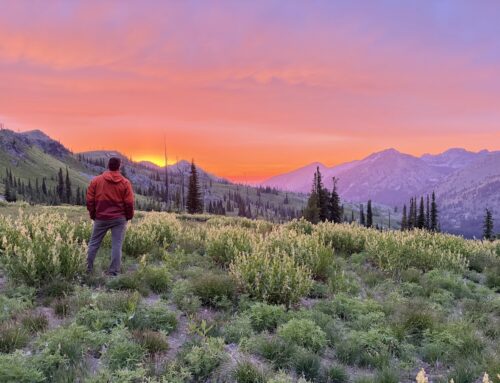
After climbing from the pass into the high country, the trail meandered through rolling high desert basins and gentle ridges. Pronghorn, elk, and mule deer darted through the sage and whitebark pines and lumbering herds of cattle stuck to the dry open meadows. Camped at the Lake of the Woods, a blood red moon hung in the smoke and the elk bugled from the trees while the birds chirped a violent cacophony to the red night. About midnight, Quality got quite the wake up call when a bear bluff charged his tent, threatened by its white conical shape in the darkness. It sniffed around his tent briefly before sauntering off, leaving Quality sleepless with his heart pounding.

Rolling over Gunsight Pass we got our first view of the Wind River Range. From the first glance, I knew this was going to be some of the most spectacular hiking of my life. The high desert dropped away dramatically into the Green River Valley with wildly craggy peaks, massive square-top mesas, and giant granite monoliths hanging high overhead. Descending into the valley, the Green River Lakes mirrored the canyons jagged walls. Passing some old homesteader cabins at the mouth of the canyon, we hiked to the far end of the lakes and set up camp.
The next day, we began our climb up to the headwaters of the Green River. The scenery intensified with every bend in the emerald green and chalky waters of the river. As the river got smaller, the valley got rockier and steeper. Soon, we climbed a series of passes (Vista Pass and Cube Rock Pass) only to end up back at the basin where the Green River begins. The high country in the Winds is like an M.C. Escher drawing of interconnected catacombs, linked by tiny passes high up on the ridges like a stony maze of impossible perspectives. The trail petered out as I approached Knapsack Col, high on the wall above at about 12,200 feet. It was about an hour’s scramble on large talus rocks to reach the col, and the view from the top was absolutely mind-blowing. It was a 360 degree view of some of the most impressive peaks I’ve seen (and some climbed by ITA’s own Tom Dabrowski). I didn’t have long to hang around and enjoy it though, as the sun was setting and it was a long way down into Titcomb Basin on the South side of the pass. The way down was steep on loose scree across space that the drastically reduced Twin Glacier used to occupy. I zig zagged through the loose rock, hopping on and off the tracks of the climbers who’d come before me. Down in the treeless basin, I set up my tent in a human-made windbreak, staring back at Knapsack Col and the surrounding peaks in the full moon light while I ate my ramen dinner.

In the morning I hiked 17 miles to the Elkhart Trailhead to try and hitch into Pinedale. We got a ride with a gal named Racheal who had to clear it with her teenage daughters before they let some smelly hikers into their car. They were more than happy to oblige though, and shared info on all the Pinedale hot spots. Racheal also mentioned that she had some friends working on a local trails organization, trying to improve trail conditions in their area. Well, we had plenty to talk about in that regard and soon she was dropping us off at the Jackalope Motor Lodge and hostel.
We booked our rooms and immediately set to eating whatever we could find. I worked my way through my town chores: shower, laundry, resupply, shipping out a box at the post office, hitting up the outfitter for a pair of gloves, and more eating. After that it was time to veg out in a nice clean hotel room, in clean clothes, with clean feet and hair. I made some phone calls, watched a movie, ate some more, and slept like a rock.
Ready to hit the trail again, I looked up a fellow named Alex on the trail angel list and asked if he could give me a ride back to the trailhead. He was happy to do so, and when he showed up, he was wearing a Sublette Trails Association hat (sublettetrails.org). Turns out he was involved with starting the program and he knew Racheal as well. We talked about trails stewardship and all the many challenges and rewards that come with such work. Sounds like they have plenty to do in their neck of the woods, as the Winds trails were fairly busy and the trailheads packed with cars from all over the country.
Hiking back into the Southern Winds, I had my eyes set on the Cirque of the Towers alternate. However, the weather had other plans. The first cold snap of fall weather struck with a shower of torrential rain that lasted all morning. I stayed dry in my tent, hoping it would pass but it only relented to a light drizzle. I packed up my wet tent and got a move on, but the rain continued. After a few hours the rain turned to hail and soon the thunderclaps followed, ringing through the canyon walls between peaks hidden in the low clouds. I sheltered up in my tent and let the weather pass. For a brief moment, the sun pierced through the clouds and provided the first opportunity all day for a little warmth. I packed up my tent again and hiked a few more miles, fruitlessly trying to dry my clothes. It rained again all night, making for a damp but warm night’s sleep.
The rain continued the next day in almost the exact same pattern, but the temperatures had plummeted. The rainy hiking became a hypothermia survival game of changing layers, sheltering up, and drying things out in the brief moments of sunshine. That night, the rain turned to sleet and left my tent encrusted in a sheet of ice. With all my layers on, I decided that an off-trail traverse over several passes through the Cirque of the Towers was not the best idea in these conditions, and opted instead to make a full send effort to the Big Sandy Lodge, just off the official CDT route. The comments described “the best burger on the trail” and “real home made food.” Well, after 3 days of rain I figured it’d be worth it to go try one for myself. Maybe I could do laundry, get a room and a hot shower; as long as I could get warm and dry. Due to all the rain, I was behind schedule and running low on food. So maybe the folks at the lodge would be so kind as to pack me a sandwich to go, to bolster my food supply.

I set out in the cold morning air in a light rain, hiking to warm up. After 20 minutes I was warm enough to feel my toes again and I powered through the 12 miles to the lodge. Imagine my disappointment on discovering that it had already closed for the season. There wasn’t a soul around. As I walked back towards the trail with my head hanging low, the sky began to clear up. Soon, the clouds broke up and drifted away over the Winds. I set up a dry line and hung my tent, sleeping bag and jackets out to finally dry and took a nice long but rationed snack break in the sun. I took a road back up to the CDT which quickly turned to single track through aspen meadows and then opened up to my first view of the Southern Winds since leaving Pinedale.
Feeling restless from being cooped up in my tent and on my fourth day of a four day resupply, I was motivated to rip some miles. The sky was clear and the trail was fast and flowy, so I figured it would be a great time to do some night hiking. I chugged a big caffeine drink and went flying down the trail, winding through alternating aspen and pine groves, the miles melting away… for about an hour.
Just as the sun was starting to set, I came around a corner and ran into a solid wall of dead fall. According to my navigation app, there was a spring just inside the blowdowns so I crawled my way about 30 feet in towards the sound of trickling water. I was going up and over piles 8 feet high. There was no way I was going to do this all night! So I turned back and set up camp at the edge of the downed trees. Apparently a huge wind event and knocked trees down over the trail for the next 7-8 miles, and judging by the comments on the app, the CDT hikers were not having fun going through it. Resigned to camp, I settled into my sleeping bag with caffeine running through my veins.
That night, the quiet of the post-stormy night, was interrupted by the piercing bugling of the bull elk in rut. It was the most incredible display of elk bugling I have ever heard. It sounded like there were half a dozen bulls in the draw with me, blowing their frustrated calls, challenging each other for their opportunity to mate in the coming weeks. I laid awake listening for hours. There is something so beautiful in their haunting calls. It is so palpably wild that it touches the most unknown and primitive parts inside yourself, sending a chill down your spine.
Having packed up camp in the morning, I set off into the blow downs. After about a mile of making my way through the jungle gym, I’d had enough and hopped onto an elk trail. The game trail turned into a cow trail, and then turned into a dirt road. Eventually, I went cross country across the sagebrush and easily made my way around the jumbled mess of trees. Back on the trail I hiked another 20 mile day to my resupply box at South Pass City. I arrived 6 days after leaving Pinedale, having planned for 4. Needless to say I was running lean and I ate my last hand full of Reese’s Pieces as I strolled into town.
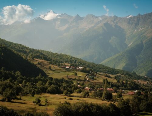
South Pass City is an old gold boom town that busted in the 1870’s. The State of Wyoming has preserved all the remaining buildings and furnished them with period furniture and knick knacks. The self guided walking tour was free for hikers, so I bought a couple ice cream bars in the gift shop and took a spin around town. The nearby town of Atlantic City was the last stop of my day so I collected my box, packed up my food, and headed out past a slew of abandoned gold diggings and dilapidated mills.

Atlantic City is a casino and beach boardwalk town on the coast of New Jersey. It is also a town of about 37 people hidden in a Wyoming gulch on the edge of the Great Divide Basin. You can guess which one I was at. I got a room in a small 1 bed cabin with an electric blanket for a heater at Wild Bill’s Bed and Breakfast. At the one restaurant in town, I sat down with three Great Divide bikers: Mike from Chicago, Bart from the Netherlands, and Steven from Kamloops. They turned out to be great company and were also staying at Wild Bills. In the morning I reunited with the bikers and 3 adventure motorcyclists for a family style pancake breakfast in the dining room of The Miner’s Delight hotel. Bill had carefully restored this relic of the mining era and we had eggs, sausage, pancakes and coffee in a turn of the century boom town dining room. The western history in this area is imbued in every building and character in town.
Next up is the Great Basin; 200 miles of desert road walking that will take us through Rawlins and on to Colorado… where there will be many more cold nights to come. Time to add the winter gear to the pack and brace for the next phase! The snow is coming.
Cheers,
-Clay “Woodward” Jacobson


Damn Man! That 12 miles up and back to a closed lodge sounds rough. But Wind Rivers sound and look amazing! Keep up the footwork Buddy!
I am really enjoying your blog. Good luck.
An amazing adventure Clay. Embrace the brutality.