Our Trail Spotlight highlights day trips to multi-day hikes across Idaho. Trail conditions can change quickly- swollen rivers can become impassable, windstorms can knock trees down across trails, and snow can come earlier than expected. Please take these recommendations as a jumping off place and do additional research to understand current conditions and keep yourself safe if you choose to hike this trail. Physical guidebooks and maps are always good to have or check out some online resources like Alltrails.com for updated trail reports. If your trip is as awesome as you hope it will be, please share photos and feedback!

Photo curtesy Brendan Blowers de León
Recommended by: Brendan Blowers de León, ITA Crew Leader
Duration: Day Hike
Area: Morley Nelson Snake River Birds of Prey National Conservation Area
Difficulty Rating: 4/5: steep, rocky, unstable footing
Road Considerations: Road is paved up to trailhead. However, most mobile phones will lose signal once you descend into the canyon, and GPS maps often route cars down Victory Lane (part of which is navigable by low-clearance vehicles, but unpaved, uneven, and muddy), rather than on Sinker Road, which is paved up to the trailhead. Nearest services (bathrooms, water, free wifi and daytime park staff) are at Celebration Park ¼ mile from trailhead, which is also the best location to search for on a mapping app.
Total hiking miles: 3.1 miles out-and-back
The Hike:
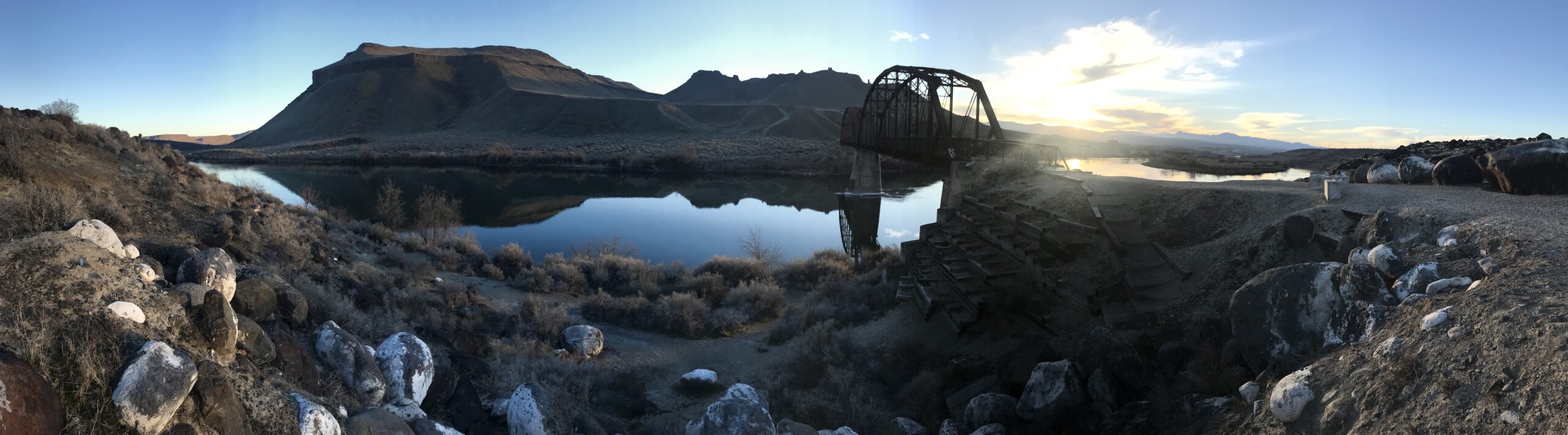
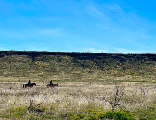
The hike begins by walking across the Snake River on the historic Guffey train bridge, constructed in 1897 and used for about 50 years to transport supplies and people from Murphy into Nampa. The bridge was restored and pedestrian access constructed in 1990. This is a prime birding area, and year-long residents and water birds will be some of the rare wildlife you will see in the winter season, though you might spot a Mountain Cottontail rabbit or a coyote. Celebration Park is site SW19 on the Idaho Birding Trail, and you can spot herons, eagles, kestrels, and hawks. The plants (and wildlife) you spot here are true year-long high-desert survivors; they tough out the harsh winter conditions while most everything else migrates or dies off.
After crossing the bridge, a steep scramble down the berm gets you into a short section of sagebrush/saltbrush steppe before peeling upward to the right for a steep ascent up to a higher plain. Be sure take the ascent to the RIGHT, this will get you on the path up Guffey Butte, instead of toward the left butte, with steep cliffs. After the brief, steep ascent, a level section precedes another steep portion straight up the side of Guffey Butte. The side of the slope is the remnant of a prehistoric volcanic eruption back when the Yellowstone hotspot used to be positioned under southwest Idaho. As you summit the “saddle” of the smaller butte with all the gnarly tuff cones and spires, the terrain under your feet will change to gravelly lava rock where someone has created a “geoglyph” (a rock arrangement visible from above). The saddle area is a false summit, but scramble around to your left in the rock formation to climb through the circular hole that has been weathered through the rock (“window” rock). At this point you’ve ascended the steepest part, but you’re only ¾ mile in and halfway to the actual summit. Already, the views to the north are majestic, across the Snake River and Guffey Bridge to other prominent geological features (Hat Butte, Walter’s Butte, White Butte, and Initial Point).
Descend the north slope of the ridge, and the trail will continue to the right, past the volcanic spires, and swoop up another steep slope. You can’t see the summit from the trail… but it is there… due North from the trail, which peters out at the base of the slope. You can follow the faint trace of the trail up to the ridge and toward the right… but any ascent you take will get you closer to the actual summit of Guffey Butte. Technically you are ascending a second, higher volcanic peak, through a maar formation created rising magma that mixed with water and erupted, causing more shallow, sloping craters.
You’ll know you’re at the true peak at 3123 feet when you encounter a towering rock cairn with an American flag in it, likely shredded to bits by the violent winds on the top of the butte, with a summit log inside a toolbox cache. You’ll also have a beautiful scenic panoramic view, this time including the Owyhees: Hayden Peak and War Eagle Peak towering above the rest. You’ll also have spectacular views down into the town of Murphy (the historic terminus of the railroad crossing the Guffey Bridge).
If the wind hasn’t blown you off the butte, return the way you came or explore some of the side trails that loop around other parts of the volcanic butte or cross over to the other plateau to the east. If you’re into geocaching, search for some of those as well.
Places to camp along the way: Celebration Park campgrounds along the Snake River, first-come-first-serve. Fee is $5/night, campsites have no shade but have fire pits, pit toilets are nearby, and views of the Snake River.
Things to consider: Be aware of your surroundings. Rattlesnakes have been spotted (but are rare, especially in colder months). Steep slopes and rocks can be dangerous for a misstep, and the wind can be uncomfortably violent. Poles are nice to save your knees, and a shemagh, scarf, or buff are not out of place here. Sections may be muddy. Temperatures are dangerously hot in the summer, and there is no shade; in the winter and all times of the year, forcefully windy squalls can come along the Owyhee front or up the Snake River and pummel hikers unexpectedly. Trail to the summit is not well marked, though it’s a clear path of ascent. Cell service is spotty and unreliable.
Fun places to visit on your way in or out:
- Celebration Park Visitor’s Center – Open to the public (free guided tours of the petroglyphs) from 10am-2pm all week. The petroglyph trail is less than a mile and is very intriguing (though not well marked, use the free brochures from the kiosks in the Visitor’s Center. Look also for the “Ecology Trail” near the Visitor’s Center boat parking lot. It is a short interpretive trail (3/4 mi long) that includes ecological and cultural history about the area. Celebration Park is also a popular location for boat access and fishing on the Snake River.
- Halverson Lakes Trail is one mile away on a grated gravel road, accessible for low-clearance vehicles (though muddy and uneven). It is a level trail, a 3.3 mile loop, that includes some interpretive signage and Idaho mining/ranching history.
- Dedication Point, Swan Falls Dam, Kuna Caves, and Initial Point are nearby as well
More info about this hike:
- https://www.alltrails.com/trail/us/idaho/guffey-butte-trail
- http://www.splattski.com/2010/guffey/index.html –John Platt’s account of visiting the “chimney spire” and traversing Guffey Butte

Photo curtesy Brendan Blowers de León

Photo curtesy Brendan Blowers de León

Photo curtesy Brendan Blowers de León

Photo curtesy Brendan Blowers de León

Leave A Comment